Smart geotechnical monitoring for Landslide risk management along the Naples Bari Railway Line, Italia
As part of the construction of the Naples Bari high-capacity railway line, SOCOTEC Italia developed an advanced geotechnical investigation and monitoring system along the Telese San Lorenzo Vitulano section.
The project addressed one of the most complex challenges in infrastructure engineering: managing risk in an area affected by a dormant landslide, potentially reactivated by the excavation of a tunnel approximately 80 meters deep.
Through an integrated, data-driven approach, SOCOTEC transformed the subsoil into a monitored, analyzable, and interpretable system in real time, supporting both design and operational decision-making.
Key information
- Project Name: Smart Geotechnical Monitoring for Landslide Risk Management along the Naples–Bari Railway Line
- Date: 2021
- Client: Telese Scarl (on behalf of Rete Ferroviaria Italiana)
- Location: Benevento (Italy)

Talk to our experts


Project details
The new Naples–Bari railway line, promoted by Rete Ferroviaria Italiana, represents a strategic infrastructure for enhancing mobility in Southern Italy.
Along the Telese San Lorenzo Vitulano section, the alignment crosses a complex geomorphological context characterized by slope instability and mapped landslides. In the municipality of Ponte (BN), in particular, a dormant landslide area was identified, whose equilibrium could be affected by underground construction works.
The construction of the railway tunnel, planned at a depth of approximately 80 meters, introduces a critical variable: the interaction between excavation activities and ground behavior.
The challenge
The project required answering a key question :
How can the behavior of an unstable slope be monitored and predicted in relation to a deep underground structure?
This was not only about data acquisition, but about:
1#
Building a reliable geological-geotechnical model.
2#
Extending point-based knowledge to a volumetric scale.
3#
Continuously monitoring deep ground deformations.
4#
Transforming data into actionable information for risk management.
In other words, shifting from a static understanding of the subsoil to a dynamic and predictive interpretation.
The SOCOTEC Approach
To address this complexity, SOCOTEC Italia developed an integrated system based on three pillars

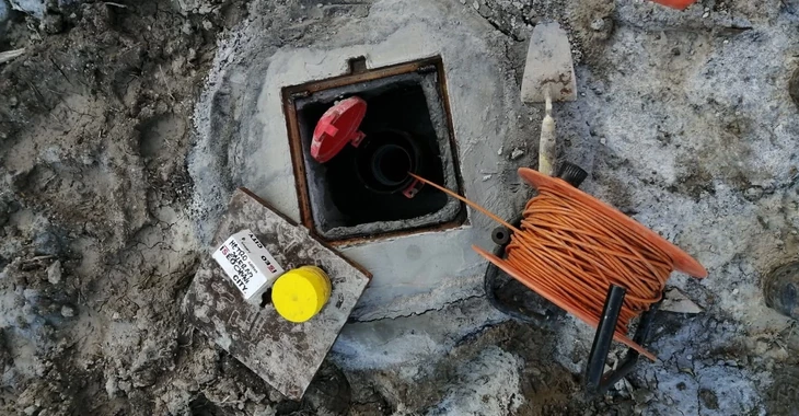
Advanced technologies for monitoring landslide movements
From data to decision
The value of the project lies in the ability to integrate data from multiple sources into a single interpretative system.
The adopted approach made it possible to:
- correlate ground deformations with excavation activities;
- continuously monitor the evolution of the landslide phenomenon;
- support timely and informed decision-making;
- reduce geotechnical risk during construction.
In this perspective, monitoring is no longer just a control tool, but becomes an active component of project management.
Risk management
Towards predictive monitoring

This project represents a concrete step towards risk management models based on data integration and advanced technologies.
The combined use of distributed sensors, geophysical investigations, and geotechnical modeling lays the foundation for predictive monitoring systems, where data is used not only to describe current conditions, but also to anticipate future scenarios.
Thanks to the adopted approach, it was possible to:
- increase the level of subsoil knowledge;
- improve the reliability of the geotechnical model;
- ensure continuous control of deep deformations;
- reduce risks associated with tunnel construction;
- contribute to the safety and sustainability of the infrastructure.
A new paradigm for infrastructure
In complex contexts such as the Naples Bari railway line, geotechnical risk management requires a paradigm shift: from static approaches to dynamic, integrated, and intelligent systems.
This project demonstrates how the integration of engineering, advanced sensing technologies, and data management can transform the subsoil into a system that is observable, interpretable, and governable.